Valley of Flowers National Park - India


Valley of Flowers National Park is an Indian national park, Nestled high in West Himalaya, is renowned for its meadows of endemic alpine flowers and outstanding natural beauty. It is located in Uttarakhand state. This richly diverse area is also home to rare and endangered animals, including the Asiatic black bear, snow leopard, brown bear and blue sheep. The gentle landscape of the Valley of Flowers National Park complements the rugged mountain wilderness of Nanda Devi National Park. Together they encompass a unique transition zone between the mountain ranges of the Zanskar and Great Himalaya. The park stretches over an expanse of 87.50 km².

The Valley of Flowers is an outstandingly beautiful high-altitude Himalayan valley that has been acknowledged as such by renowned mountaineers and botanists in literature for over a century and in Hindu mythology for much longer. Its ‘gentle’ landscape, breathtakingly beautiful meadows of alpine flowers and ease of access complement the rugged, mountain wilderness for which the inner basin of Nanda Devi National Park is renowned.

Valley of flower is splashed with colour as it bloomed with hundreds different beautiful flowers, taking on various shades of colours as time progressed. Valley was declared a national park in 1982, and now it is a World Heritage Site. The locals, of course, always knew of the existence of the valley, and believed that it was inhabited by fairies.

While trekking towards valley of flowers, one can experience the beauty of shining peaks fully covered with snow. One can also see the beautiful view of surrounding greenery and various running streams with crystal clear water.

The valley is home to many celebrated flowers like the Brahmakamal, the Blue Poppy and the Cobra Lily. It is a much sought after haunt for flower-lovers, botanists and of course trekkers, for whom a sufficient excuse to embark on a mission to reach a place, is that it exists.

The Valley of Flowers is internationally important on account of its diverse alpine flora, representative of the Western Himalayan alpine shrub and meadows ecoregion. The rich diversity of species reflects the valley’s location within a transition zone between the Zaskar and Great Himalayas ranges to the north and south, respectively, and between the Eastern Himalaya and Western Himalaya flora. A number of plant species are internationally threatened, several have not been recorded from elsewhere in Uttarakhand and two have not been recorded in Nanda Devi National Park. The diversity of threatened species of medicinal plants is higher than has been recorded in other Indian Himalayan protected areas. The entire Nanda Devi Biosphere Reserve lies within the Western Himalayas Endemic Bird Area (EBA). Seven restricted-range bird species are endemic to this part of the EBA.

The Valley of Flowers was declared a national park in 1982. This part of Uttarakhand, in the upper reaches of Garhwal, is inaccessible through much of the year. The area lies on the Zanskar range of the Himalayas with the highest point in the national park being Gauri Parbat at 6,719 m above sea level.

History
According to the Ramayan this is the place where Hanuman searched for Sanjivani Booti to cure Lakshman when he was injured by Indrajit(Meghnada), the son of Ravana.

The place had disappeared from the tourist map due to its inaccessible approach but in 1931 Frank S. Smythe a British mountaineer lost his way while returning from a successful expedition to Mt.Kamet and happened upon this valley which was full of flowers. He was so attracted towards the beauty of the place he named it the "Valley of Flowers". He authored a book called "The Valley of Flowers" which unveiled the beauty and floral splendours of the valley and thus threw open the doors of this verdant jewel to nature-enthusiasts all over the world.

In 1939 Miss Margaret Legge, a botanist deputed by the Royal Botanic Gardens Edinburgh arrived at the valley for further studies. While she was traversing some rocky slopes to collect flowers, she slipped off and was lost forever. Her sister later visited the valley and erected a memorial near the spot. The memorial is still there.

Prof. Chandra Prakash Kala, a botanist deputed by the Wildlife Institute of India, carried out a remarkable research study on the floristics and conservation of the valley for a decade starting in 1993. He made an inventory of 520 alpine plants exclusively growing in this national park and authored two important books - "The Valley of Flowers - Myth and Reality" and "Ecology and Conservation of the Valley of Flowers National Park, Garhwal Himalaya'.
There is no settlement in the national park and grazing in the area has been banned. The park is open only in summer between June and October, being covered by heavy snow during the rest of the year.

Fauna & Flora
The park is home to tahr, snow leopard, musk deer, red fox, common langur, bharal, serow, Himalayan black bear, Himalayan brown bear, Pika (Mouse hare) and a huge variety of butterflies. Among the important birds and Pheasant are, Himalayan Golden Eagle, Griffon Vulture, Snow Partridge, Himalayan Snowcock, Himalayan Monal, Snow Pigeon, Sparrow Hawk etc.

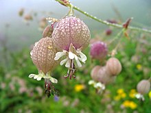
Flowers mostly orchids, poppies, primulas, marigold, daisies and anemones carpet the ground. Alpine forests of birch and rhododendron cover parts of the park's area. A decade long study of Prof. C.P. Kala from 1993 onwards concludes that the Valley of Flowers endows with 520 species of higher plants (angiosperms, gymnosperms and pteridophytes), of these 498 are flowering plants. The park has many species of medicinal plants including Dactylorhiza hatagirea, Picrorhiza kurrooa, Aconitum violaceum, Polygonatum multiflorum, Fritillaria roylei and Podophyllum hexandrum.


Source, Images: http://en.wikipedia.org/wiki/Valley_of_Flowers_National_Park

Dok Bua Tong field - Thailand


Mae Hong Son, Thailand’s second northern most province, is sheltered by several high mountains and has a cool climate almost all year round. Mae Hong Son is approximately 924 kilometers from Bangkok and around 250 kilometers from Chiang Mai. Mae Hong Son is bordered by the Union of Myanmar (Burma) to the north and the west. A strong Burmese influence can be seen throughout the province’s temples and buildings’ architect. The population of Mae Hong Son include Thai Yai, which is the minority from Shan state and various hill tribes such as Karen, Hmong, Lahu, Lua and Lisu, scattering in the districts.

A national park in Mae Hong Son Province on the Doi Mae U-kor, Mae Surin National Park is blessed with waterfalls and a vast field of wild sunflowers (bua thong) which bloom in November. You can visit a Hill Tribe in Khun Yuam district. However getting to this national is in itself a challenge as Mae Hong Son Province is over 900 km from Bangkok and can be reached by air and then by road to Khun Yuam district and on a further 90 km to Doi Mae U-kor.

The Mae Hong Son province of Thailand is awash with golden hues in November as its wild sunflowers burst into bloom. The Bua Tong (a wild sunflower with the scientific name tithonia diversifolia) is celebrated in Khum Yuam and another great site to view the flowers is Doi Mae U-Kor. When the flowers fade, the seeds are collected to make insecticides.

From the 1st November 2006 up to the 15th December 2006, visitors will witness a spectacular scenery in Thailand at the Doi Mae U-kor mountain peak in Khun Yuam district of Mae Hong Son province in Thailand. The hills and valleys seen here, one of Thailand’s most naturally scenic areas, turn to amazing golden color when the Dok Bua Tong wild sunflowers comes into full bloom during this time of the year.

Trip route from Khun Yuam district is quite tortuous. You have to go up and down along the hillside slope. (picture) Along 108 highway (Mae Hong Son – Khun Yuam). Leave 1 kilometer before reaching the Khun Yuam, turn left to Highway No 1263, along 26 kilometers on asphant road. You will see a picture of yellow field from long distance.

Blossom period of Bua Tong is Nov till late Dec every year. The gigantic size of Bua Tong field covers more than 1,000 rai. In the afternoon, sunlight becomes orange and beautiful color of Bua Tong that impress all visitors.

Thung Dok Bua Tong (the Mexican sunflower field), (Thai: ทุ่งดอกบัวตอง) is particularly popular at the end of the year. During this time, this mountainous region turns a brilliant yellow as the Bua Tong flowers reach their full bloom. Sunflowers are gradually went down when you drive far away. However, you still drive along the hillside and have a good chance of taking a panoramic picture.

During the season, a lot of tourists mainly come from Bangkok. Tent setting is on the hill top. Some came with a tour company, so food and accommodation are more convenient. Toilet is also available but farther down from hill. You may choose to sleep in a local hut below the hill, near Doi Mae U-kor. Rate should be around 500 Bht/night.

Cool throughout the year. It is very cold in the winter. There are heavy fogs in the morning and cold during the day because of the wind blows all day long. It’s Hill Evergreen Forest and Pine Evergreen Forest. Most of Hill Evergreen Forest has been found in the north and west of Tung Bua Tong. Flora species grown around the hill slope and valley consist of Castanopsis species and so on.

In the eastern and southern part of Tung Bua Tong, Pine Evergreen Forest has been found. It’s planted by the Forest Industry Organization based on its concession condition. Flora species found are Pinus merkusii and Pinus kesiya.


Source, Images: http://www.thailandtravelpro.com/bua-tong-flower-field/

Siam Tulip (Dok Kra Jiao)


The Siam Tulip or Summer Tulip (Curcuma alismatifolia) (Thai: ปทุมา, pathuma, or ดอกกระเจียว, dok krajiao) is a tropical plant native to northern Thailand and Cambodia. Despite its name, it is not related to the tulip, but to the various ginger species such as turmeric. It can grow as an indoor plant, and is also sold as cut flowers.

One of the most famous wild fields of Siam Tulips is in the Pah Hin Ngam National Park in the Chaiyaphum province of Thailand. Kra Jiao or Siam Tulip is local annual plant, which found normally from Lan Hin Ngam to Sud Paen Din Viewpoint. The viola pink Siam Tulip will bloom at the beginning of rainy-from June to August.

The unique geographical landscape of Chaiyaphum Province in the northeast of Thailand gives rise to a range of natural attractions of exceptional beauty. Of these, the fields of pinkish-purple Siam Tulip, or “Dok Kra Jiao” (Thai: ดอกกระเจียว), come in to full bloom in the early part of the rainy season. Held over two months each year, the Blooming Kra Jiao Flower Festival celebrates the “Dok Kra Jiao” flower which blooms at this time of the year. The flowers grow in abundance in Pah Hin Ngam (Forests of Beautiful Rock) National Park which hosts this annual festival. Known as the “Siam tulip”, the sight of these pinkish-purple flowers in bloom is a wonderful spectacle.

Also commonly called ‘pathuma’, ‘bua sawan’ (heaven lotus), or ‘bua bok’ (the land lotus), the Siam Tulip is a member of the ginger genera – Curcuma or Zingiberaceae. The unusual form, bright colour and long-lasting quality of the Siam Tulip has made it an increasingly popular choice for floral decorations. It is in high demand and is currently being cultivated in the form of cuttings or ornamental plants for local consumption as well as for export overseas, predominantly to Japan and the Netherlands.


Sources, Images: http://en.wikipedia.org/wiki/Siam_Tulip, http://www.thailandtravelpro.com/fields-of-siam-tulip/

Pah Hin Ngam National Park - Thailand


Pah Hin Ngam (Thai: ป่าหินงาม) is a National Park in Chaiyaphum province in Thailand. The name Hin Ngam means beautiful stone, where Pa means forest.

In 1985, the Tep Satit Forestry Department first surveyed the area, long popular with the locals, and recommended its protection. In October 1986, the Pah Hin Ngam Park was created, covering 10 km² around the strange rock formations which gave the park its name. In 1993, the Forestry Department of Thailand conducted a more thorough survey including the surrounding area, and recommended that it become a national park. The national park covering 112 km² was created on September 19, 1994, which was officially gazetted in 2007.

The park is located at the boundary of the Phetchabun mountain range with the Korat Plateau. The steep cliff at the 846 m high Sut Phan Din viewpoint allows a great view into a valley of the Sonthi River and the Sap Langka Wildlife Sanctuary. The name Sut Phan Din (Thai: สุดแผ่นดิน) means end of land, reflecting the steepness of the cliff. This cliff also marks the watershed between the Chao Phraya and the Mekong rivers.
Near the viewpoint is one of the fields of the Siam Tulip (Curcuma alismatifolia), called Dok Kra Jiao ดอกกระเจียว in Thai. The dipterocarp forests bloom with the purple flowers at the beginning of the raining season in July.

The park got its name from the strange rock formations in the Hin Ngam Rock Ground, located at the western end of the park. Erosion has carved several large rocks into striking and unusual shapes.

The forest is semi-evergreen forest mixed with deciduous forest. The main plants are Siamese sal, ingyin, Burmese ebony, Lithocarpus collettii A. Camus, Payom (a kind of Dipterocarpaceae), pride of India, San (a kind of Dilleniaceae) etc. Animals found are barking deer, wild boar, hare, pangolin, porcupine, bamboo rat, palm civet, squirrel, monkey etc.

The best time to visit the fields of Dok Kra Jiao, over 1000 rai, is in the early mornings as there is quite a difference in the display according to the time of day. You can park your vehicle at the wide-open parking space on the left of the national park and then ride in the local “Song-taew”. You can be dropped off anywhere along the route at recognized vantage points and back again right where you got on.


Source, Images: http://en.wikipedia.org/wiki/Pa_Hin_Ngam_National_Park